
WP 4 Community Resilience
Communities (neighborhoods, villages or municipalities) play a vital role during and after a disastrous event. The capability of local communities to prepare for, act during, and recover after a crisis is commonly referred to as community resilience. The generic problem dealt with in WP4 is: How can community resilience be increased by understanding its 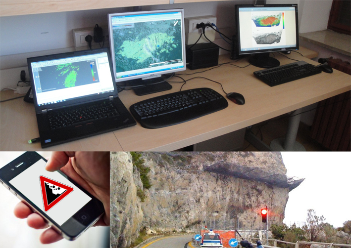 nature, and improving stakeholder awareness, communication and participation?
Surveys will be carried out to explore the role of community resilience in the phases of prevention and preparedness (monitoring, risk perception, training/exercises, and early warning), and disaster response and recovery (evacuation and coping capacity). WP4 will focus on social capital and community competence as well as communication of risk information before, during and after disasters, as community resilience depends on effective interaction between scientists, other experts, the general public, media, emergency managers and policy makers.
WP4 includes 3 tasks:
Task 4.1 Unpacking and measuring community resilience
Team: NTNU: Haakon Lein (WP leader) , Gunhild Setten, UI: Guðrún Gísladóttir, Guðný Eydal, NCIP: Guðrún Jóhannesdóttir.
The problem: A number of international studies have set out to unpack the concept and drivers of community resilience, as well as to identify relevant indicators. However, the concept of community resilience in relation to natural hazard has not been much explored in a Nordic context and the relevance of indicators identified for Nordic communities remains to be investigated.
The study: The study sets out to investigate how resilience is constituted and enacted across a set of Nordic communities. Research questions to be addressed are: Which factors contribute to community resilience and which community resources can be/are mobilized in a crisis situation? How can aspects of community resilience be measured? How can community resilience be strengthened? Case studies will be performed in Nordic communities that have experienced disasters to explore the role of community resilience in the phases of prevention, preparedness, response and recovery. A common set
of issues will be explored to allow comparison a) according to hazard type, b) between communities with and without previous disaster experience c) between the Nordic countries.
Task 4.2 Risk perception
Team: UI: Guðrún Gísladóttir (WP leader), Ingibjörg Lilja Ómarsdóttir, Deanne Bird. NCIP: Guðrún Jóhannesdóttir, NTNU:Haakon Lein, FMI: Hilppa Gregow, Reija Ruuhela,Atte Harjanne, SGI: Lisa Van Well
The problem: Understanding, awareness and effective communication about natural hazards and risks are vital for appropriate preparedness both among the general public and policymakers. Authorities need to utilize public as well as scientific knowledge to gain understanding of potential hazards and learn how best to warn the public. Experience has shown that different groups respond differently to warning messages. The source of the  information and the method of delivery are of key importance.
The study: A comparative Nordic study of how risk perception to natural hazards is affected by demographic, technical and societal factors. Through which channels and from which sources do people get their information and which sources of information do they trust best? To what extent do types of channels and sources and type of information affect the inclination to pro-act or react? How do policymakers and emergency managers utilize current knowledge and how is it best communicated?
Task 4.3 Participatory early warning and monitoring systems for natural hazards
Team: GEUS: Hans Jørgen Henriksen (WP leader), Peter van der Keur, IMO:Matthew J. Roberts, Philippe Crochet, FMI: Adriaan
Perrels and Atte Harjanne.
The problem: Early warning and monitoring systems are sparse or lacking in many hazardous areas, making it difficult to issue timely public warnings or follow the process of hazardous events as they unfold. For flooding hazards, water level data can make real time hydrological modelling of flooding more accurate and enable improved forecasts of damage on critical infrastructure hours or days before the hazard occurs. The public can provide  in-situ photographs of water levels, snow banks, forest fires, or other phenomena. Critical infrastructure stakeholders can also upload local time series of e.g. water levels and flow measurements to a real time modelling system. Improved participation can encourage the public to respond to warnings and be better prepared for flooding hazards, and allow critical infrastructure stakeholders to better navigate in hazard situations by improved understanding of interdependencies and the whole system (e.g. transport, water supply/waste water, energy supply).
The study: The study will investigate novel ways of expanding various monitoring techniques with network-based public participation. The goal is to incorporate public observations into existing monitoring networks and real time modelling and forecasting systems so that: (i) more timely and accurate warnings can be issued; (ii) more comprehensive compilations of damage effects targeting various critical infrastructure are received; and (iii) public risk perception and hazard awareness are improved.
The study will include a review of different participatory early warning, monitoring and modelling systems and techniques, focussing on the merits of real-time public participation in the communication of, for instance, changing groundwater and river levels. Next, case studies are selected in the Nordic countries for developing and testing participatory early warning systems and preparation of stakeholder involvement plans targeting critical infrastructure stakeholders. This will be followed by a review of user needs from experts within the consortium as well as from the public, emphasising design and piloting of a web interface prototype so that different types of hazards can be handled and visualised
(allowing uploading of local observations). In the next phase we will develop a method for compiling,processing and quality assuring the uploaded data in datasets to facilitate statistical analyses, develop flooding indicators and data assimilation techniques to protect critical infrastructures. A prototyped web interface will be tested in cooperation with experts from the consortium and observers who have uploaded the data.